The history of the site Asheville is considering for a performing arts center
Click here to go back to the GAP Report on this issue.
Families rooted on Eagle Street
For more than forty years, the stretch of Eagle Street between South Spruce and Davidson, now known as “Parkside,” was home to multi-generational Black families rooted in Asheville’s historic Block. That continuity would not last.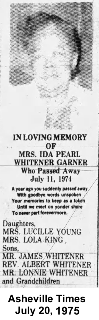
At 74 Eagle Street, members of the Hentz and Abrams families lived in the same home for more than forty years. Next door, at 76 Eagle, the Whitener/Garner family did the same. City directories show a steady continuity of residence—parents, children, and extended kin—anchored in place across generations.
The life of Ida Pearl Whitener Garner, who rented furnished rooms at 76 Eagle for decades, offers a glimpse into that continuity. She raised a family whose presence extended into the next generation, and when she died in 1974, she left behind children, grandchildren, and a homeplace that had anchored her family’s life in Asheville. Her life, rooted in this place, spanned the very period when the City began to reshape neighborhoods like this one. Within a decade of her death, her home—and others like it—would be gone.
Not all of the land that makes up the present-day “Parkside” site followed the same path. Portions of the block—including the site of the former Buncombe County Jail—were publicly owned much earlier, while others remained in private hands into the late 20th century. This history is not uniform. But across these parcels, a consistent pattern emerges: residential uses gave way to clearance, and the land was ultimately assembled for a different civic purpose.
How “substandard housing” became a justification for displacement
By the early 1950s, the City of Asheville had begun to systematically target neighborhoods like this one.
City officials and local real estate leaders described large portions of Black Asheville as “substandard” and in need of intervention. Reports emphasized housing conditions—structural deterioration, overcrowding, and code violations—while largely ignoring the forces that had produced those conditions.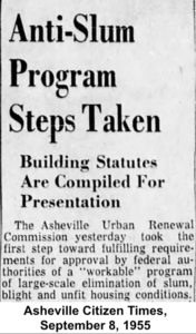
Black homeowners faced well-documented barriers to credit and financing. In practice, this meant that families who owned their homes often had little or no access to the loans needed to make repairs or improvements. Properties deteriorated not simply because of neglect, but because of systemic disinvestment. Conditions created by disinvestment were then used as justification for removal.
This created a self-reinforcing cycle:
- homes were labeled “substandard”
- investment was denied
- deterioration continued
- and the designation of “blight” was used to justify further intervention
Across Asheville, these conditions became the basis for clearance efforts that would reshape entire neighborhoods. The details of ownership differ from parcel to parcel. But the outcome is the same: a residential landscape—shaped in part by Black homeownership—was cleared, and the land was repurposed without meaningful participation from the people most connected to it.
Across Asheville, these conditions became the basis for clearance efforts that would reshape entire neighborhoods. The details of ownership differ from parcel to parcel. But the outcome is the same: a residential landscape—shaped in part by Black homeownership—was cleared, and the land was repurposed without meaningful participation from the people most connected to it.
From homes to vacant land
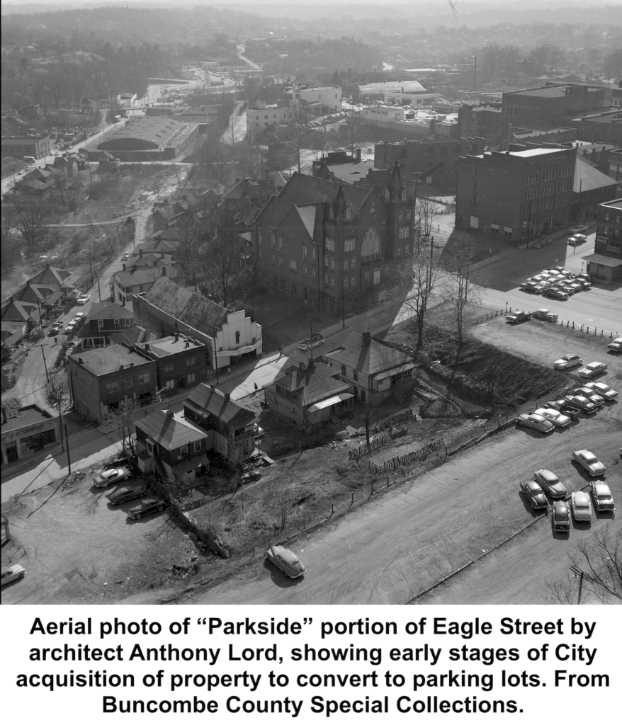
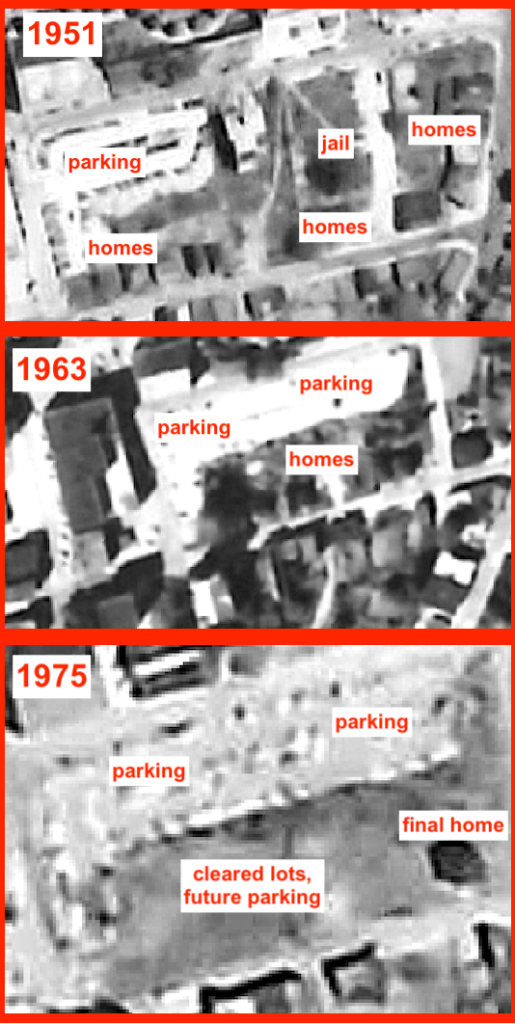
By the 1970s, most of the homes along the Eagle Street block had been removed, and the land reduced to vacant lots. City directories show the shift: long-occupied homes becoming “vacant,” and then disappearing from the record altogether. Photographs used for urban renewal and other redevelopment project planning show the shifting landscape.
This transformation of historical structures was irreversible . Once the homes and businesses were leveled, the value they added to the community was erased. The City could then acquire the parcels more cheaply.
Not urban renewal—but the same result
In the mid-20th century, “urban renewal” was a federal program that paid cities to clear areas labeled “blighted” and redevelop them for new uses. As referenced above, these designations often fell on Black neighborhoods that had been denied access to credit and investment, and their resulting conditions were then used to justify demolition. Municipal governments acquired these properties—frequently by threatening eminent domain—and displaced residents. When redevelopment commenced, the benefits rarely flowed back to the original inhabitants of these communities. While framed as progress, urban renewal often meant the removal of well-established Black neighborhoods in service of new development priorities.
The City has stated that the Eagle Street properties were not part of a federally designated urban renewal project. That is technically true, but it does not tell the full story. While some parcels had long been in public ownership, others were acquired from Black homeowners under conditions that closely mirrored the dynamics of urban renewal—disinvestment, designation as substandard, clearance of homes, and eventual conversion to other uses. What emerges is a familiar pattern of displacement; the only thing distinguishing it from urban renewal is federal government involvement.
When it came to the property that would eventually be branded “Parkside,” the City had a local objective: expanding parking to serve the growing needs of City Hall and downtown development.
By the early 80’s, only a few of the many properties that had once lined Eagle Street remained outside of government control, so the CIty prepared to use the power of eminent domain to seize the rest of them – the exact same mechanism that facilitated urban renewal.
Acquisition through pressure—and force
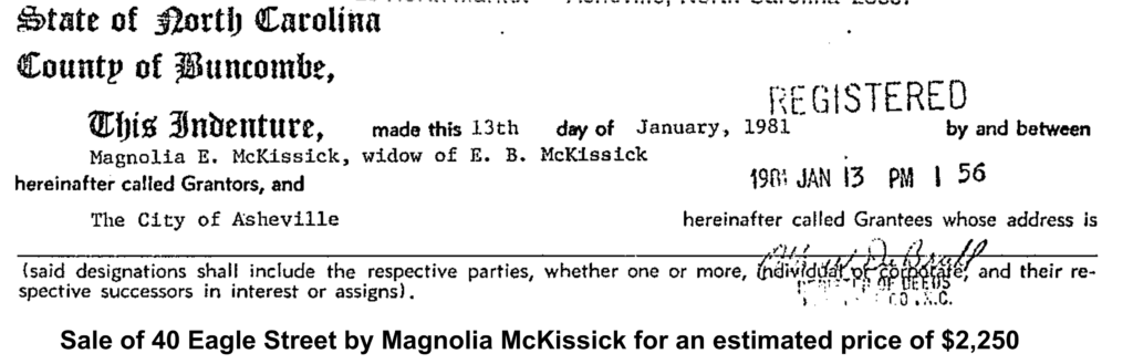
In 1981, the City began assembling the parcels that make up the “Parkside” site today. Some properties, like 40 Eagle Street, were acquired directly from private owners. Others, including 74 and 76 Eagle Street, were taken through eminent domain. Taken together, these actions consolidated land that had once included both long-standing Black-owned homes and publicly held property into a single site for municipal use.
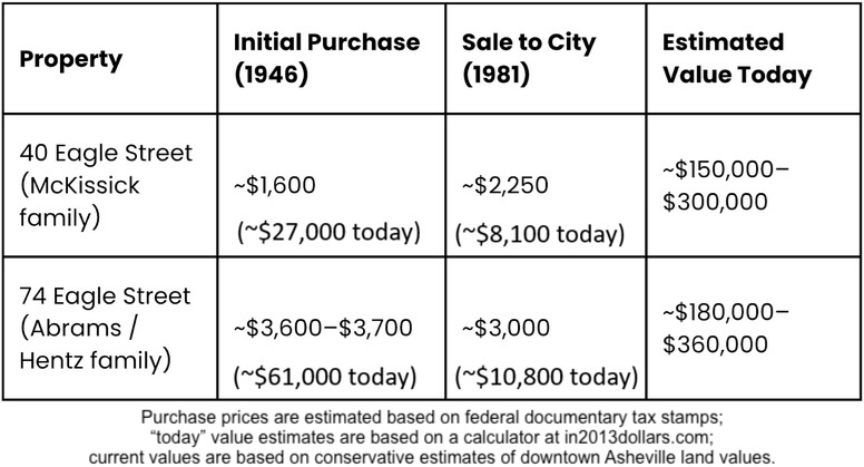
Under the threat of eminent domain litigation from the City, some owners agreed to sell. In January 1981, Magnolia McKissick, mother of Civil Rights leader Floyd McKissick, sold her family’s property at 40 Eagle Street to the City for roughly $2,250, which translates into $8,100 in today’s dollars. The family had purchased the property for $1,600 in 1946, which translates into $27,000 in today’s dollars—so a net loss in generational wealth of the equivalent of $25,400.
Others did not—or could not—agree to the City’s terms. Just a few months after buying the McKissick lot, the Asheville City Council authorized the use of eminent domain to take the remaining properties at 74 and 76 Eagle Street.
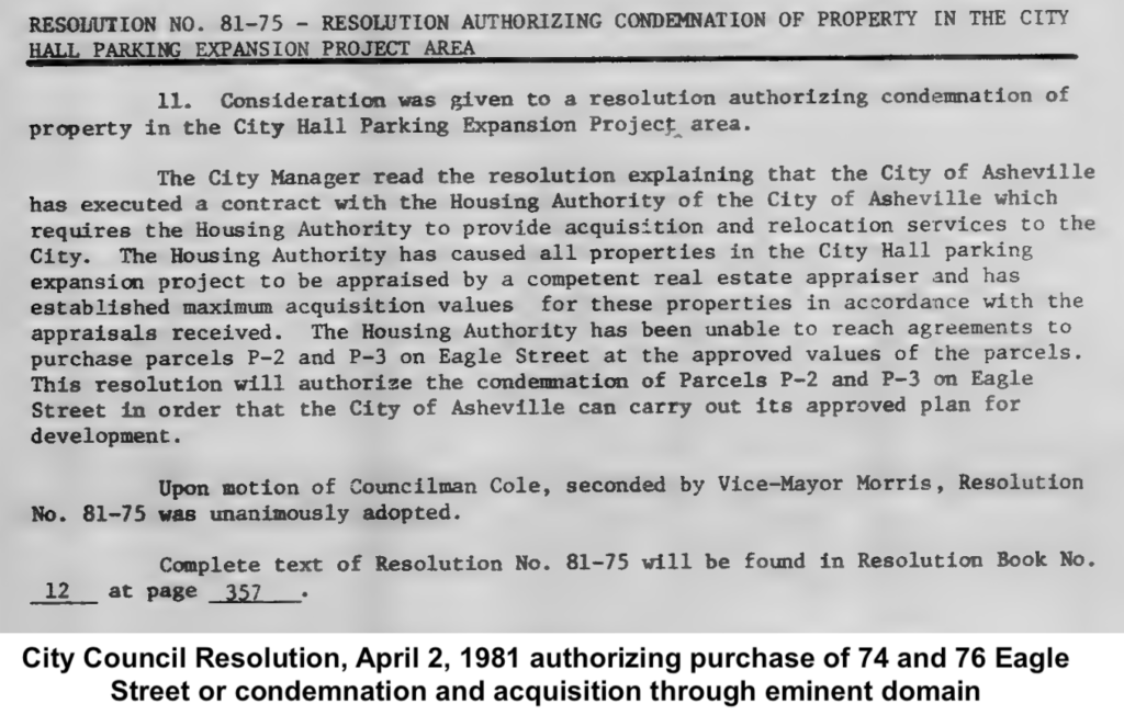
Legal filings show the breadth of those affected: multiple members of the Abrams/Hentz family, along with heirs and descendants, all named as parties in the proceeding.
What had once been a single-family home had become, over generations, a shared inheritance—and all of it was subject to seizure.
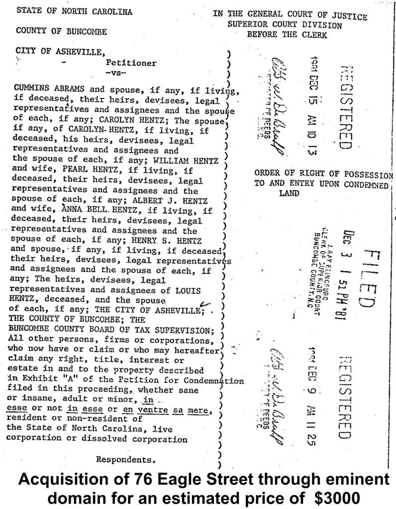
The Abrams Wentz family sold their lot for an estimated $3000, or $10,800 in today’s dollars. They had orginally purchased it in 1946 for an estimated $3600, which translates into $61,000 today. So their familial net loss of $50,200 was even greater than that of the McKissick’s.
In 2003, the City completed its assembly of the site by acquiring additional parcels from Buncombe County, including land that had long been in public ownership. By that point, the transformation of the Eagle Street block from residential use to parking was complete.
What was lost—and what comes next
These homes were not high-value properties when they were first purchased—roughly $1,500 to $3,500 in the 1940s—but they were stable, long-term family homes. Over the following decades, instead of appreciating, they were devalued, cleared, and ultimately acquired by the City for only a few thousand dollars. Today, the land they occupied is worth many times that amount.
By looking at aerial photographs, you can see the progression from a mostly residential neighborhood in the 50’s to a parking lot and just one remaining home in the late 70’s. Once that home was gone, in the early 1980s, this block of Eagle Street—once home to generations of Black Asheville residents—had been transformed into surface parking. The City government achieved its goal. But the cost was borne by the families who had lived there, and by a community that lost housing, wealth, inheritance, and a piece of its physical presence in the center of the city.
 These decisions were not inevitable—they were choices reflecting whose presence the government valued, and whose they did not.
These decisions were also not inclusive—they were made without any meaningful participation by the community members who would be most impacted.
Although the City conducted various forms of “community engagement” throughout the 1950’s and 60’s when this larger displacement process was underway, the residents of this stretch of Eagle Street, just like the rest of Black Asheville, were given no reasonable opportunity to advocate against the destruction of their neighborhoods.
In Part 3, we’ll look at what happened next: how this land has been used (and how various plans for its use have surfaced) in the decades since the City acquired it—and what this history means as Asheville considers what to do with this land now. We will continue to ask this central question: Will those who stand to be most impacted by the City’s decisions have a real “seat at the table” in the process as it unfolds, or will their voices, once again, be drowned out? Will the enduring Black communities on The Block be invited to help build its future, or will they be expected to make way for the City’s priorities?
Click here to go back to the GAP Report on this issue.